Ewell night lights from space
Night Light of Ewell (England) from space (United Kingdom) Src. Average luminocity for 10x10km area is 68.2927% and for 50x50km: 52.9214%.
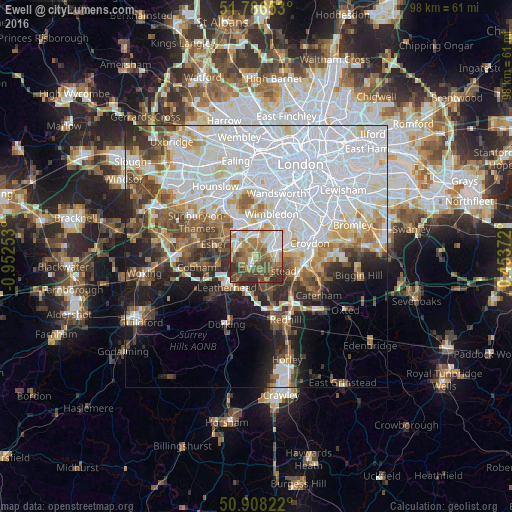

Analysis of Ewell night lights 2016
Square area 10x10 km:
 13.87%
90-99
14.01%80-89
6.02%70-79
9.1%60-69
19.33%50-59
12.75%40-49
12.75%30-39
9.24%20-29
2.94%10-19
0%0-9
0%Square area 50x50 km:
22.57%90-99
11.38%80-89
4.31%70-79
4.23%60-69
4.59%50-59
4.69%40-49
5.3%30-39
4.61%20-29
5.67%10-19
7.99%0-9
24.64%Clear (daylight) street map image can be seen on geolist.org.
Map coordinates:
51° 47' 11.5" North, 0° 57' 9.1" West
51° 20' 58.1" North, 0° 14' 57.8" West
50° 54' 29.6" North, 0° 27' 13.4" East
Some cities around Ewell sort by population:
• Sutton
3.4 km =2.1 mi,  89°
89°
• Banstead
4.2 km =2.6 mi,  135°
135°
• Epsom
2.6 km =1.6 mi,  214°
214°
• Chessington
4.1 km =2.5 mi,  290°
290°
• Hook
4.5 km =2.8 mi,  297°
297°
• Worcester Park
3.4 km =2.1 mi,  5°
5°
• Ashtead
5.7 km =3.5 mi,  217°
217°
• Cheam
2.5 km =1.6 mi,  56°
56°
6690867 (p: 39,994)
Sources (retrieved 2019-11-25):
» Earth at Night: Flat Maps 2012, 2016