Abertridwr night lights from space
Night Light of Abertridwr (Wales) from space (United Kingdom) Src. Average luminocity for 10x10km area is 37.5267% and for 50x50km: 19.6584%.
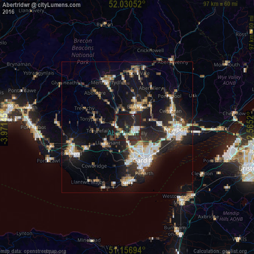
Analysis of Abertridwr night lights 2016
Square area 10x10 km:
 5.35%
5.35%90-99
6.82%80-89
2.81%70-79
4.14%60-69
2.54%50-59
3.61%40-49
4.81%30-39
9.63%20-29
30.48%10-19
29.01%0-9
0.8%Square area 50x50 km:
3.1%90-99
3.71%80-89
1.52%70-79
2.15%60-69
2%50-59
2.05%40-49
2.47%30-39
3.18%20-29
7.24%10-19
16.92%0-9
55.68%Clear (daylight) street map image can be seen on geolist.org.
Map coordinates:
52° 1' 49.9" North, 3° 58' 17.2" West
51° 35' 45" North, 3° 16' 6" West
51° 9' 25" North, 2° 33' 54.7" West
Some cities around Abertridwr sort by population:
• Caerphilly
4.2 km =2.6 mi,  124°
124°
• Pontypridd
5.1 km =3.2 mi,  277°
277°
• Gelligaer
7.7 km =4.8 mi,  6°
6°
• Nelson
6.5 km =4 mi,  350°
350°
• Bedwas
4.8 km =3 mi,  95°
95°
• Beddau
7.8 km =4.8 mi,  233°
233°
• Abercynon
6.9 km =4.3 mi,  323°
323°
• Hengoed
6.6 km =4.1 mi,  22°
22°
3345315 (p: 6,504)
Sources (retrieved 2019-11-25):
» Earth at Night: Flat Maps 2012, 2016