Bedwas night lights from space
Night Light of Bedwas (Wales) from space (United Kingdom) Src. Average luminocity for 10x10km area is 33.8997% and for 50x50km: 19.4171%.
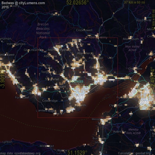
Analysis of Bedwas night lights 2016
Square area 10x10 km:
 4.14%
4.14%90-99
5.08%80-89
2.41%70-79
2.27%60-69
2.14%50-59
2.81%40-49
3.21%30-39
12.7%20-29
35.83%10-19
28.74%0-9
0.67%Square area 50x50 km:
3.05%90-99
3.68%80-89
1.39%70-79
1.97%60-69
1.94%50-59
2.24%40-49
2.47%30-39
3.27%20-29
7.18%10-19
16.47%0-9
56.33%Clear (daylight) street map image can be seen on geolist.org.
Map coordinates:
52° 1' 35.6" North, 3° 54' 7.2" West
51° 35' 30.6" North, 3° 11' 55.9" West
51° 9' 10.4" North, 2° 29' 44.7" West
Some cities around Bedwas sort by population:
• Caerphilly
2.3 km =1.4 mi,  214°
214°
• Risca
7 km =4.3 mi,  75°
75°
• Gelligaer
9 km =5.6 mi,  333°
333°
• Blackwood
8.5 km =5.3 mi,  355°
355°
• Nelson
9 km =5.6 mi,  319°
319°
• Abercarn
7.6 km =4.7 mi,  35°
35°
• Abertridwr
4.8 km =3 mi,  275°
275°
• Hengoed
6.9 km =4.3 mi,  340°
340°
2656033 (p: 8,242)
Sources (retrieved 2019-11-25):
» Earth at Night: Flat Maps 2012, 2016