Wintzenheim night lights from space
Night Light of Wintzenheim (Grand Est) from space (France) Src. Average luminocity for 10x10km area is 35.0028% and for 50x50km: 11.1799%.
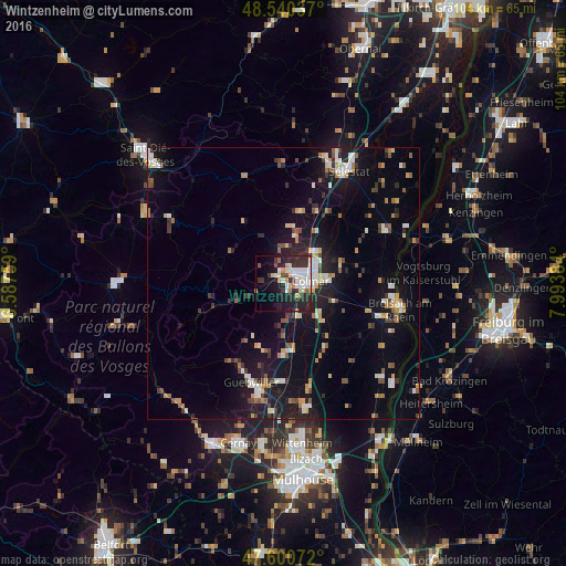
Analysis of Wintzenheim night lights 2016
Square area 10x10 km:
 7.1%
7.1%90-99
9.09%80-89
3.27%70-79
3.69%60-69
2.13%50-59
1.99%40-49
1.42%30-39
5.54%20-29
18.04%10-19
20.88%0-9
26.85%Square area 50x50 km:
1.3%90-99
1.99%80-89
0.81%70-79
1.42%60-69
1.17%50-59
1.02%40-49
1.27%30-39
1.5%20-29
2.87%10-19
10.26%0-9
76.4%Clear (daylight) street map image can be seen on geolist.org.
Map coordinates:
48° 32' 25.3" North, 6° 35' 15.3" East
48° 4' 21.7" North, 7° 17' 26.6" East
47° 36' 2.6" North, 7° 59' 37.8" East
Some cities around Wintzenheim sort by population:
• Colmar
4.9 km =3 mi,  79°
79°
• Breisach am Rhein, DE
22.2 km =13.8 mi,  101°
101°
• Guebwiller
18.6 km =11.6 mi,  201°
201°
• Soultz-Haut-Rhin
21 km =13 mi,  192°
192°
• Ensisheim
23.4 km =14.5 mi,  169°
169°
• Sainte-Marie-aux-Mines
20.9 km =13 mi,  337°
337°
• Horbourg-Wihr
7.7 km =4.8 mi, 83°
• Munster
11.8 km =7.3 mi,  252°
252°
2967337 (p: 7,845)
Sources (retrieved 2019-11-25):
» Earth at Night: Flat Maps 2012, 2016