Breisach am Rhein night lights from space
Night Light of Breisach am Rhein (Baden-Württemberg) from space (Germany) Src. Average luminocity for 10x10km area is 20.3892% and for 50x50km: 14.5565%.
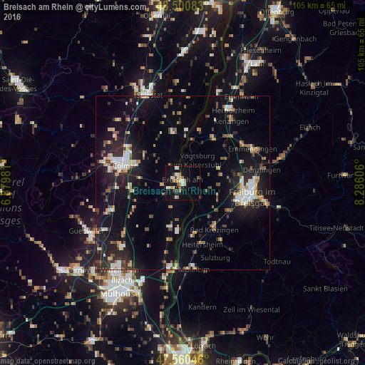
Analysis of Breisach am Rhein night lights 2016
Square area 10x10 km:
 2.7%
2.7%90-99
3.84%80-89
0.85%70-79
3.55%60-69
4.12%50-59
1.7%40-49
1.28%30-39
2.41%20-29
1.42%10-19
23.72%0-9
54.4%Square area 50x50 km:
1.75%90-99
2.27%80-89
1.13%70-79
1.81%60-69
1.42%50-59
1.67%40-49
1.74%30-39
2.09%20-29
4.41%10-19
12.68%0-9
69.04%Clear (daylight) street map image can be seen on geolist.org.
Map coordinates:
48° 30' 3" North, 6° 52' 47.3" East
48° 1' 58" North, 7° 34' 58.6" East
47° 33' 37.7" North, 8° 17' 9.8" East
Some cities around Breisach am Rhein sort by population:
• Unterkrozingen
14.9 km =9.3 mi,  147°
147°
• Endingen
15 km =9.3 mi,  35°
35°
• Schallstadt
15.4 km =9.6 mi,  122°
122°
• Ihringen
4.9 km =3 mi,  76°
76°
• Vogtsburg
8.4 km =5.2 mi,  31°
31°
• Horbourg-Wihr, FR
15 km =9.3 mi,  290°
290°
• Bötzingen
11.6 km =7.2 mi,  65°
65°
• Umkirch
13.7 km =8.5 mi,  89°
89°
2944800 (p: 14,367)
Sources (retrieved 2019-11-25):
» Earth at Night: Flat Maps 2012, 2016