Sainte-Marie-aux-Mines night lights from space
Night Light of Sainte-Marie-aux-Mines (Grand Est) from space (France) Src. Average luminocity for 10x10km area is 0.9107% and for 50x50km: 8.4005%.
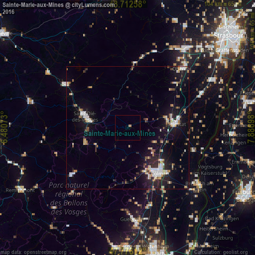
Analysis of Sainte-Marie-aux-Mines night lights 2016
Square area 10x10 km:
 0%
0%90-99
0%80-89
0%70-79
1.19%60-69
0%50-59
0%40-49
0%30-39
0%20-29
0%10-19
0%0-9
98.81%Square area 50x50 km:
1.17%90-99
1.59%80-89
0.74%70-79
0.88%60-69
0.87%50-59
0.57%40-49
0.87%30-39
1.08%20-29
2.45%10-19
7.34%0-9
82.44%Clear (daylight) street map image can be seen on geolist.org.
Map coordinates:
48° 42' 45.3" North, 6° 28' 50.6" East
48° 14' 47.4" North, 7° 11' 1.9" East
47° 46' 34" North, 7° 53' 13.1" East
Some cities around Sainte-Marie-aux-Mines sort by population:
• Colmar
22.4 km =13.9 mi,  145°
145°
• Sélestat
19.7 km =12.2 mi,  84°
84°
• Obernai
32.6 km =20.3 mi,  42°
42°
• Gérardmer
29.8 km =18.5 mi,  229°
229°
• Wintzenheim
20.9 km =13 mi,  157°
157°
• Barr
26.5 km =16.5 mi,  47°
47°
• Horbourg-Wihr
24.1 km =15 mi,  139°
139°
• Munster
23.1 km =14.4 mi,  188°
188°
2980438 (p: 6,189)
Sources (retrieved 2019-11-25):
» Earth at Night: Flat Maps 2012, 2016