Horbourg-Wihr night lights from space
Night Light of Horbourg-Wihr (Grand Est) from space (France) Src. Average luminocity for 10x10km area is 40.5461% and for 50x50km: 11.399%.
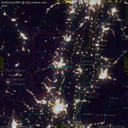
Analysis of Horbourg-Wihr night lights 2016
Square area 10x10 km:
 10.57%
90-99
11.46%80-89
3.42%70-79
4.32%60-69
1.19%50-59
1.79%40-49
2.53%30-39
3.57%20-29
21.73%10-19
17.41%0-9
22.02%Square area 50x50 km:
1.28%90-99
1.83%80-89
0.95%70-79
1.46%60-69
1.18%50-59
1.27%40-49
1.34%30-39
1.44%20-29
2.87%10-19
9.76%0-9
76.62%Clear (daylight) street map image can be seen on geolist.org.
Map coordinates:
48° 32' 55.2" North, 6° 41' 26.4" East
48° 4' 51.8" North, 7° 23' 37.7" East
47° 36' 33" North, 8° 5' 48.9" East
Some cities around Horbourg-Wihr sort by population:
• Colmar
2.8 km =1.7 mi,  269°
269°
• Sélestat
20.5 km =12.7 mi,  11°
11°
• Breisach am Rhein, DE
15 km =9.3 mi,  110°
110°
• Guebwiller
23.3 km =14.5 mi,  218°
218°
• Wintzenheim
7.7 km =4.8 mi,  263°
263°
• Ihringen, DE
19.3 km =12 mi,  102°
102°
• Vogtsburg, DE
18.5 km =11.5 mi,  84°
84°
• Munster
19.4 km =12.1 mi, 256°
3013155 (p: 5,358)
Sources (retrieved 2019-11-25):
» Earth at Night: Flat Maps 2012, 2016