Guebwiller night lights from space
Night Light of Guebwiller (Grand Est) from space (France) Src. Average luminocity for 10x10km area is 23.2983% and for 50x50km: 15.7495%.
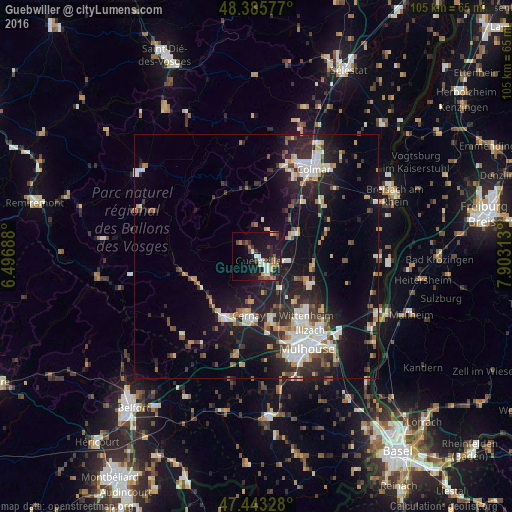
Analysis of Guebwiller night lights 2016
Square area 10x10 km:
 2.41%
2.41%90-99
4.55%80-89
1.28%70-79
1.99%60-69
3.13%50-59
2.98%40-49
4.97%30-39
4.12%20-29
3.69%10-19
30.68%0-9
40.2%Square area 50x50 km:
2.83%90-99
2.83%80-89
1.15%70-79
1.86%60-69
1.31%50-59
1.54%40-49
1.79%30-39
2.43%20-29
5.13%10-19
12.81%0-9
66.3%Clear (daylight) street map image can be seen on geolist.org.
Map coordinates:
48° 23' 8.8" North, 6° 29' 48.8" East
47° 55' 0" North, 7° 12' 0" East
47° 26' 35.8" North, 7° 54' 11.3" East
Some cities around Guebwiller sort by population:
• Wittenheim
15.1 km =9.4 mi,  141°
141°
• Kingersheim
16.9 km =10.5 mi,  145°
145°
• Cernay
12 km =7.5 mi,  188°
188°
• Wittelsheim
12.3 km =7.6 mi,  165°
165°
• Thann
14.1 km =8.8 mi,  210°
210°
• Soultz-Haut-Rhin
3.8 km =2.4 mi, 145°
• Ensisheim
12.6 km =7.8 mi,  116°
116°
• Munster
14.5 km =9 mi,  341°
341°
3014433 (p: 12,548)
Sources (retrieved 2019-11-25):
» Earth at Night: Flat Maps 2012, 2016