Munster night lights from space
Night Light of Munster (Grand Est) from space (France) Src. Average luminocity for 10x10km area is 2.1918% and for 50x50km: 9.6444%.
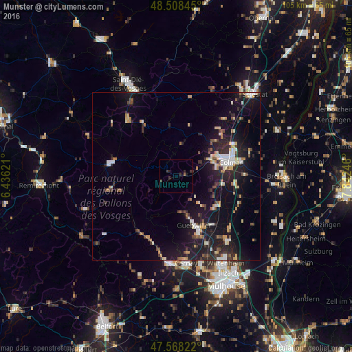
Analysis of Munster night lights 2016
Square area 10x10 km:
 0%
0%90-99
0%80-89
0%70-79
0%60-69
0.28%50-59
0.28%40-49
0%30-39
3.13%20-29
1.42%10-19
0.28%0-9
94.6%Square area 50x50 km:
1.06%90-99
1.53%80-89
0.8%70-79
1.24%60-69
0.87%50-59
0.86%40-49
1.01%30-39
1.47%20-29
3.37%10-19
10.58%0-9
77.21%Clear (daylight) street map image can be seen on geolist.org.
Map coordinates:
48° 30' 30.4" North, 6° 26' 10.4" East
48° 2' 25.7" North, 7° 8' 21.6" East
47° 34' 5.6" North, 7° 50' 32.9" East
Some cities around Munster sort by population:
• Colmar
16.7 km =10.4 mi,  74°
74°
• Guebwiller
14.5 km =9 mi,  161°
161°
• Gérardmer
19.8 km =12.3 mi,  280°
280°
• Wintzenheim
11.8 km =7.3 mi, 72°
• Soultz-Haut-Rhin
18.2 km =11.3 mi, 158°
• Sainte-Marie-aux-Mines
23.1 km =14.4 mi,  8°
8°
• Horbourg-Wihr
19.4 km =12.1 mi,  76°
76°
• La Bresse
20.9 km =13 mi,  257°
257°
2991189 (p: 5,162)
Sources (retrieved 2019-11-25):
» Earth at Night: Flat Maps 2012, 2016