Ensisheim night lights from space
Night Light of Ensisheim (Grand Est) from space (France) Src. Average luminocity for 10x10km area is 25.0625% and for 50x50km: 17.1105%.
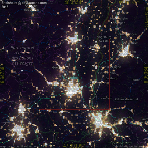
Analysis of Ensisheim night lights 2016
Square area 10x10 km:
 2.56%
2.56%90-99
2.98%80-89
2.56%70-79
3.41%60-69
1.7%50-59
1.85%40-49
2.98%30-39
4.26%20-29
16.48%10-19
34.23%0-9
26.99%Square area 50x50 km:
2.73%90-99
2.79%80-89
1.2%70-79
2%60-69
1.63%50-59
1.84%40-49
2.1%30-39
2.54%20-29
4.95%10-19
15.54%0-9
62.67%Clear (daylight) street map image can be seen on geolist.org.
Map coordinates:
48° 20' 7.4" North, 6° 38' 50.6" East
47° 51' 57" North, 7° 21' 1.9" East
47° 23' 31.2" North, 8° 3' 13.1" East
Some cities around Ensisheim sort by population:
• Wittenheim
6.3 km =3.9 mi,  195°
195°
• Illzach
10.2 km =6.3 mi,  179°
179°
• Kingersheim
8.5 km =5.3 mi,  192°
192°
• Guebwiller
12.6 km =7.8 mi,  296°
296°
• Wittelsheim
10.3 km =6.4 mi,  232°
232°
• Pfastatt
11.3 km =7 mi, 198°
• Soultz-Haut-Rhin
9.4 km =5.8 mi,  285°
285°
• Sausheim
8.9 km =5.5 mi,  169°
169°
3020152 (p: 6,940)
Sources (retrieved 2019-11-25):
» Earth at Night: Flat Maps 2012, 2016