Viroflay night lights from space
Night Light of Viroflay (Île-de-France) from space (France) Src. Average luminocity for 10x10km area is 82.1676% and for 50x50km: 67.3449%.
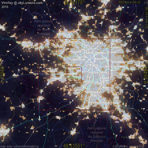
Analysis of Viroflay night lights 2016
Square area 10x10 km:
 22.73%
90-99
24.57%80-89
10.65%70-79
10.94%60-69
17.05%50-59
10.09%40-49
3.69%30-39
0.28%20-29
0%10-19
0%0-9
0%Square area 50x50 km:
31.33%90-99
16.54%80-89
4.89%70-79
4.77%60-69
5.09%50-59
4.37%40-49
5.71%30-39
4.22%20-29
4.87%10-19
7.3%0-9
10.91%Clear (daylight) street map image can be seen on geolist.org.
Map coordinates:
49° 15' 42.4" North, 1° 27' 31.3" East
48° 48' 2.8" North, 2° 9' 42.5" East
48° 20' 7.8" North, 2° 51' 53.8" East
Some cities around Viroflay sort by population:
• Versailles
2 km =1.2 mi,  278°
278°
• Le Chesnay
3.8 km =2.4 mi,  309°
309°
• Vélizy-Villacoublay
3.1 km =1.9 mi,  131°
131°
• Chaville
2 km =1.2 mi,  74°
74°
• Ville-d’Avray
3.4 km =2.1 mi,  42°
42°
• Vaucresson
4.5 km =2.8 mi,  355°
355°
• Jouy-en-Josas
4.7 km =2.9 mi,  172°
172°
• Buc
3.8 km =2.4 mi,  224°
224°
2967934 (p: 16,137)
Sources (retrieved 2019-11-25):
» Earth at Night: Flat Maps 2012, 2016