Vaucresson night lights from space
Night Light of Vaucresson (Île-de-France) from space (France) Src. Average luminocity for 10x10km area is 88.6989% and for 50x50km: 68.2555%.
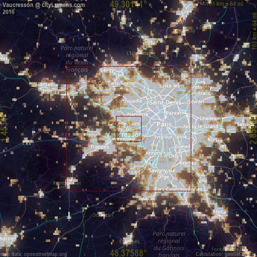
Analysis of Vaucresson night lights 2016
Square area 10x10 km:
 32.95%
90-99
32.1%80-89
8.52%70-79
11.22%60-69
9.38%50-59
2.7%40-49
3.13%30-39
0%20-29
0%10-19
0%0-9
0%Square area 50x50 km:
31.26%90-99
16.63%80-89
5.04%70-79
4.83%60-69
5.28%50-59
4.42%40-49
5.83%30-39
4.57%20-29
6.18%10-19
8.18%0-9
7.79%Clear (daylight) street map image can be seen on geolist.org.
Map coordinates:
49° 18' 5.1" North, 1° 27' 12.2" East
48° 50' 26.8" North, 2° 9' 23.5" East
48° 22' 33.2" North, 2° 51' 34.7" East
Some cities around Vaucresson sort by population:
• Versailles
4.4 km =2.7 mi,  201°
201°
• Le Chesnay
3.3 km =2.1 mi,  230°
230°
• Saint-Cloud
3.4 km =2.1 mi,  80°
80°
• La Celle-Saint-Cloud
1.3 km =0.8 mi,  322°
322°
• Garches
1.9 km =1.2 mi,  85°
85°
• Ville-d’Avray
3.3 km =2.1 mi,  125°
125°
• Bougival
2.6 km =1.6 mi,  335°
335°
• Louveciennes
3.8 km =2.4 mi,  306°
306°
2970540 (p: 8,693)
Sources (retrieved 2019-11-25):
» Earth at Night: Flat Maps 2012, 2016