Ville-d’Avray night lights from space
Night Light of Ville-d’Avray (Île-de-France) from space (France) Src. Average luminocity for 10x10km area is 91.1364% and for 50x50km: 71.1801%.
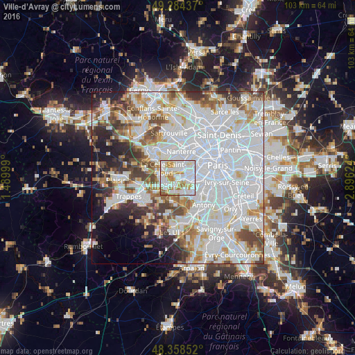
Analysis of Ville-d’Avray night lights 2016
Square area 10x10 km:
 34.52%
90-99
33.66%80-89
10.8%70-79
11.36%60-69
6.96%50-59
2.7%40-49
0%30-39
0%20-29
0%10-19
0%0-9
0%Square area 50x50 km:
33.81%90-99
17.29%80-89
5.14%70-79
5.09%60-69
5.38%50-59
4.54%40-49
5.95%30-39
4.35%20-29
4.96%10-19
5.98%0-9
7.5%Clear (daylight) street map image can be seen on geolist.org.
Map coordinates:
49° 17' 3.7" North, 1° 29' 24" East
48° 49' 24.9" North, 2° 11' 35.2" East
48° 21' 30.7" North, 2° 53' 46.5" East
Some cities around Ville-d’Avray sort by population:
• Boulogne-Billancourt
3.8 km =2.4 mi,  69°
69°
• Meudon
3.3 km =2.1 mi,  109°
109°
• Saint-Cloud
2.6 km =1.6 mi,  16°
16°
• Sèvres
1.8 km =1.1 mi,  92°
92°
• Garches
2.2 km =1.4 mi,  339°
339°
• Chaville
2 km =1.2 mi,  189°
189°
• Viroflay
3.4 km =2.1 mi,  222°
222°
• Vaucresson
3.3 km =2.1 mi,  305°
305°
2968819 (p: 11,431)
Sources (retrieved 2019-11-25):
» Earth at Night: Flat Maps 2012, 2016