Buc night lights from space
Night Light of Buc (Île-de-France) from space (France) Src. Average luminocity for 10x10km area is 70.9929% and for 50x50km: 61.2126%.
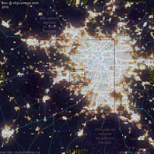
Analysis of Buc night lights 2016
Square area 10x10 km:
 16.19%
90-99
17.19%80-89
6.96%70-79
6.96%60-69
16.05%50-59
14.2%40-49
10.94%30-39
11.51%20-29
0%10-19
0%0-9
0%Square area 50x50 km:
27.77%90-99
14.96%80-89
4.48%70-79
4.04%60-69
4.65%50-59
4.05%40-49
5.19%30-39
4.19%20-29
5.66%10-19
8.64%0-9
16.37%Clear (daylight) street map image can be seen on geolist.org.
Map coordinates:
49° 14' 15" North, 1° 25' 21.5" East
48° 46' 34.6" North, 2° 7' 32.8" East
48° 18' 38.8" North, 2° 49' 44" East
Some cities around Buc sort by population:
• Versailles
3.1 km =1.9 mi,  11°
11°
• Guyancourt
3.8 km =2.4 mi,  265°
265°
• Le Chesnay
5.1 km =3.2 mi,  357°
357°
• Vélizy-Villacoublay
5 km =3.1 mi,  82°
82°
• Chaville
5.6 km =3.5 mi,  54°
54°
• Saint-Cyr-l’École
4.9 km =3 mi,  300°
300°
• Viroflay
3.8 km =2.4 mi,  44°
44°
• Jouy-en-Josas
3.7 km =2.3 mi,  120°
120°
3029695 (p: 6,120)
Sources (retrieved 2019-11-25):
» Earth at Night: Flat Maps 2012, 2016