Verrières-le-Buisson night lights from space
Night Light of Verrières-le-Buisson (Île-de-France) from space (France) Src. Average luminocity for 10x10km area is 92.2813% and for 50x50km: 68.5144%.
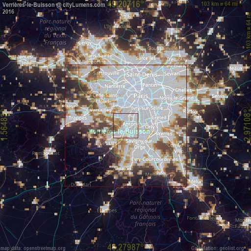
Analysis of Verrières-le-Buisson night lights 2016
Square area 10x10 km:
 40.48%
90-99
38.24%80-89
4.02%70-79
5.95%60-69
6.7%50-59
1.64%40-49
2.98%30-39
0%20-29
0%10-19
0%0-9
0%Square area 50x50 km:
32.7%90-99
16.88%80-89
4.79%70-79
4.57%60-69
5.09%50-59
4.08%40-49
5.62%30-39
4.89%20-29
5.05%10-19
4.89%0-9
11.46%Clear (daylight) street map image can be seen on geolist.org.
Map coordinates:
49° 12' 25.8" North, 1° 33' 53.4" East
48° 44' 44.3" North, 2° 16' 4.7" East
48° 16' 47.5" North, 2° 58' 15.9" East
Some cities around Verrières-le-Buisson sort by population:
• Antony
2.3 km =1.4 mi,  68°
68°
• Massy
2.4 km =1.5 mi,  152°
152°
• Châtenay-Malabry
2.2 km =1.4 mi,  357°
357°
• Palaiseau
3.3 km =2.1 mi,  203°
203°
• Fresnes
4.1 km =2.5 mi, 74°
• Le Plessis-Robinson
4.8 km =3 mi,  2°
2°
• Sceaux
3.8 km =2.4 mi,  25°
25°
• Igny
3.2 km =2 mi,  267°
267°
2969692 (p: 16,789)
Sources (retrieved 2019-11-25):
» Earth at Night: Flat Maps 2012, 2016