Vendôme night lights from space
Night Light of Vendôme (Centre) from space (France) Src. Average luminocity for 10x10km area is 3.1473% and for 50x50km: 1.8765%.
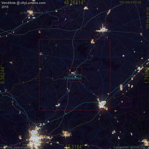
Analysis of Vendôme night lights 2016
Square area 10x10 km:
 0%
0%90-99
0%80-89
0.74%70-79
1.04%60-69
0.6%50-59
0.6%40-49
0%30-39
1.19%20-29
0.6%10-19
0.6%0-9
94.64%Square area 50x50 km:
0.27%90-99
0.37%80-89
0.25%70-79
0.18%60-69
0.29%50-59
0.16%40-49
0.14%30-39
0.21%20-29
0.35%10-19
1.5%0-9
96.28%Clear (daylight) street map image can be seen on geolist.org.
Map coordinates:
48° 15' 47.3" North, 0° 21' 44.8" East
47° 47' 34.5" North, 1° 3' 56" East
47° 19' 6.2" North, 1° 46' 7.3" East
Some cities around Vendôme sort by population:
• Blois
29.6 km =18.4 mi,  138°
138°
• Châteaudun
37 km =23 mi,  33°
33°
• Amboise
42.8 km =26.6 mi,  188°
188°
• Beaugency
42 km =26.1 mi,  91°
91°
• Vineuil
32.9 km =20.4 mi, 135°
• Meung-sur-Loire
47.3 km =29.4 mi,  84°
84°
• Mer
34.3 km =21.3 mi,  106°
106°
• Château-Renault
25.2 km =15.7 mi,  207°
207°
2970110 (p: 19,226)
Sources (retrieved 2019-11-25):
» Earth at Night: Flat Maps 2012, 2016