Amboise night lights from space
Night Light of Amboise (Centre) from space (France) Src. Average luminocity for 10x10km area is 14.7188% and for 50x50km: 6.9113%.
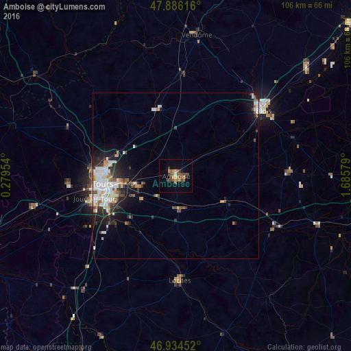
Analysis of Amboise night lights 2016
Square area 10x10 km:
 0%
0%90-99
0.57%80-89
1.56%70-79
3.41%60-69
1.99%50-59
3.84%40-49
6.39%30-39
0.99%20-29
1.28%10-19
2.56%0-9
77.41%Square area 50x50 km:
1.23%90-99
1.78%80-89
0.63%70-79
0.68%60-69
0.56%50-59
0.62%40-49
1.09%30-39
0.77%20-29
1.76%10-19
3.54%0-9
87.35%Clear (daylight) street map image can be seen on geolist.org.
Map coordinates:
47° 53' 10.2" North, 0° 16' 46.3" East
47° 24' 45" North, 0° 58' 57.6" East
46° 56' 4.3" North, 1° 41' 8.8" East
Some cities around Amboise sort by population:
• Tours
21.1 km =13.1 mi,  264°
264°
• Saint-Avertin
19.1 km =11.9 mi,  253°
253°
• Saint-Pierre-des-Corps
17.9 km =11.1 mi, 260°
• Chambray-lès-Tours
22.7 km =14.1 mi, 247°
• Montlouis-sur-Loire
11.6 km =7.2 mi, 256°
• La Riche
23.6 km =14.7 mi, 263°
• Château-Renault
20.7 km =12.9 mi,  344°
344°
• Veigné
23 km =14.3 mi,  232°
232°
3037902 (p: 12,685)
Sources (retrieved 2019-11-25):
» Earth at Night: Flat Maps 2012, 2016