Châteaudun night lights from space
Night Light of Châteaudun (Centre) from space (France) Src. Average luminocity for 10x10km area is 18.3267% and for 50x50km: 1.5042%.
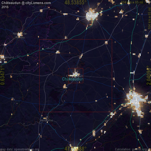
Analysis of Châteaudun night lights 2016
Square area 10x10 km:
 2.7%
2.7%90-99
4.12%80-89
1.99%70-79
1.28%60-69
1.7%50-59
3.55%40-49
1.14%30-39
1.14%20-29
1.7%10-19
13.92%0-9
66.76%Square area 50x50 km:
0.13%90-99
0.27%80-89
0.22%70-79
0.13%60-69
0.27%50-59
0.29%40-49
0.11%30-39
0.1%20-29
0.19%10-19
0.59%0-9
97.7%Clear (daylight) street map image can be seen on geolist.org.
Map coordinates:
48° 32' 18.8" North, 0° 38' 5" East
48° 4' 15.1" North, 1° 20' 16.2" East
47° 35' 56" North, 2° 2' 27.5" East
Some cities around Châteaudun sort by population:
• Vendôme
37 km =23 mi,  213°
213°
• Lucé
41.8 km =26 mi,  12°
12°
• Saran
42.2 km =26.2 mi,  108°
108°
• La Chapelle-Saint-Mesmin
42.3 km =26.3 mi,  119°
119°
• Ingré
40.1 km =24.9 mi, 114°
• Beaugency
38.8 km =24.1 mi,  146°
146°
• Luisant
41.1 km =25.5 mi, 14°
• Meung-sur-Loire
37.7 km =23.4 mi,  134°
134°
3026285 (p: 16,006)
Sources (retrieved 2019-11-25):
» Earth at Night: Flat Maps 2012, 2016