Beaugency night lights from space
Night Light of Beaugency (Centre) from space (France) Src. Average luminocity for 10x10km area is 6.0446% and for 50x50km: 8.874%.
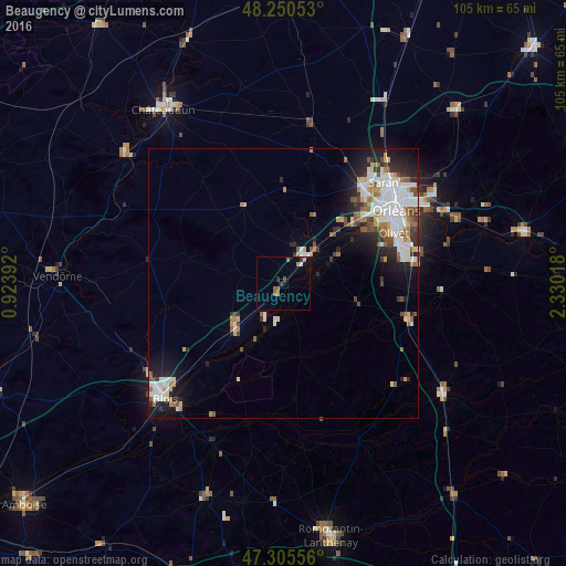
Analysis of Beaugency night lights 2016
Square area 10x10 km:
 0%
0%90-99
0.6%80-89
0%70-79
1.19%60-69
1.79%50-59
1.19%40-49
0.6%30-39
1.19%20-29
0.6%10-19
0.6%0-9
92.26%Square area 50x50 km:
1.97%90-99
2.21%80-89
0.53%70-79
0.81%60-69
1.12%50-59
1.1%40-49
0.95%30-39
0.91%20-29
1.89%10-19
4.08%0-9
84.42%Clear (daylight) street map image can be seen on geolist.org.
Map coordinates:
48° 15' 1.9" North, 0° 55' 26.1" East
47° 46' 48.7" North, 1° 37' 37.4" East
47° 18' 20" North, 2° 19' 48.6" East
Some cities around Beaugency sort by population:
• Olivet
22.3 km =13.9 mi,  65°
65°
• Saint-Jean-de-la-Ruelle
23 km =14.3 mi,  50°
50°
• La Chapelle-Saint-Mesmin
19.5 km =12.1 mi, 52°
• Ingré
21.6 km =13.4 mi,  43°
43°
• La Ferté-Saint-Aubin
24.4 km =15.2 mi,  106°
106°
• Meung-sur-Loire
7.7 km =4.8 mi, 42°
• Mer
12.3 km =7.6 mi,  227°
227°
• Saint-Pryvé-Saint-Mesmin
21.3 km =13.2 mi,  58°
58°
3034297 (p: 7,659)
Sources (retrieved 2019-11-25):
» Earth at Night: Flat Maps 2012, 2016