Meung-sur-Loire night lights from space
Night Light of Meung-sur-Loire (Centre) from space (France) Src. Average luminocity for 10x10km area is 12.5893% and for 50x50km: 8.9982%.
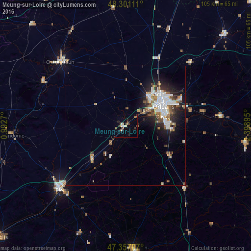
Analysis of Meung-sur-Loire night lights 2016
Square area 10x10 km:
 1.34%
1.34%90-99
1.64%80-89
0.74%70-79
1.64%60-69
2.08%50-59
1.79%40-49
1.49%30-39
1.64%20-29
3.87%10-19
1.34%0-9
82.44%Square area 50x50 km:
1.85%90-99
2.08%80-89
0.49%70-79
0.82%60-69
1.04%50-59
1.22%40-49
1.07%30-39
1.08%20-29
2.33%10-19
4.42%0-9
83.6%Clear (daylight) street map image can be seen on geolist.org.
Map coordinates:
48° 18' 4" North, 0° 59' 33.7" East
47° 49' 52.5" North, 1° 41' 45" East
47° 21' 25.5" North, 2° 23' 56.2" East
Some cities around Meung-sur-Loire sort by population:
• Orléans
17.4 km =10.8 mi,  62°
62°
• Olivet
15.6 km =9.7 mi,  77°
77°
• Saint-Jean-de-la-Ruelle
15.4 km =9.6 mi,  54°
54°
• La Chapelle-Saint-Mesmin
12 km =7.5 mi, 59°
• Saint-Jean-le-Blanc
17.8 km =11.1 mi,  67°
67°
• Ingré
13.9 km =8.6 mi,  44°
44°
• Beaugency
7.7 km =4.8 mi,  222°
222°
• Saint-Pryvé-Saint-Mesmin
14.1 km =8.8 mi, 66°
2994126 (p: 6,659)
Sources (retrieved 2019-11-25):
» Earth at Night: Flat Maps 2012, 2016