Bougival night lights from space
Night Light of Bougival (Île-de-France) from space (France) Src. Average luminocity for 10x10km area is 88.8352% and for 50x50km: 66.2549%.
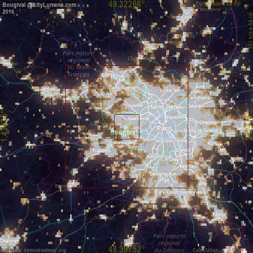
Analysis of Bougival night lights 2016
Square area 10x10 km:
 34.38%
90-99
33.38%80-89
7.1%70-79
10.09%60-69
7.24%50-59
2.7%40-49
5.11%30-39
0%20-29
0%10-19
0%0-9
0%Square area 50x50 km:
29.54%90-99
16.04%80-89
4.93%70-79
4.71%60-69
5.31%50-59
4.49%40-49
5.72%30-39
4.81%20-29
6.84%10-19
9.46%0-9
8.14%Clear (daylight) street map image can be seen on geolist.org.
Map coordinates:
49° 19' 21.6" North, 1° 26' 18.1" East
48° 51' 44" North, 2° 8' 29.3" East
48° 23' 51.1" North, 2° 50' 40.6" East
Some cities around Bougival sort by population:
• Rueil-Malmaison
3.9 km =2.4 mi,  65°
65°
• Chatou
3.3 km =2.1 mi,  22°
22°
• La Celle-Saint-Cloud
1.4 km =0.9 mi,  168°
168°
• Garches
3.7 km =2.3 mi,  126°
126°
• Le Vésinet
3.5 km =2.2 mi,  349°
349°
• Croissy-sur-Seine
1.9 km =1.2 mi, 353°
• Vaucresson
2.6 km =1.6 mi,  155°
155°
• Louveciennes
2 km =1.2 mi,  266°
266°
3031277 (p: 8,895)
Sources (retrieved 2019-11-25):
» Earth at Night: Flat Maps 2012, 2016