Trilport night lights from space
Night Light of Trilport (Île-de-France) from space (France) Src. Average luminocity for 10x10km area is 23.7557% and for 50x50km: 16.1207%.
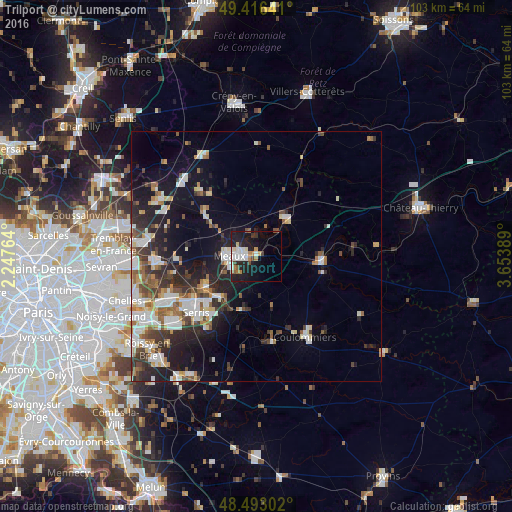
Analysis of Trilport night lights 2016
Square area 10x10 km:
 5.26%
5.26%90-99
4.12%80-89
1.7%70-79
1.99%60-69
3.55%50-59
1.7%40-49
2.7%30-39
1.42%20-29
6.68%10-19
24.29%0-9
46.59%Square area 50x50 km:
2.91%90-99
3.38%80-89
1.38%70-79
1.32%60-69
1.96%50-59
1.93%40-49
2.09%30-39
2.68%20-29
4.83%10-19
9.61%0-9
67.93%Clear (daylight) street map image can be seen on geolist.org.
Map coordinates:
49° 24' 59.1" North, 2° 14' 51.5" East
48° 57' 24.7" North, 2° 57' 2.7" East
48° 29' 34.9" North, 3° 39' 14" East
Some cities around Trilport sort by population:
• Meaux
5.3 km =3.3 mi,  273°
273°
• Coulommiers
18.6 km =11.6 mi,  148°
148°
• Thorigny-sur-Marne
18.7 km =11.6 mi,  245°
245°
• La Ferté-sous-Jouarre
12.9 km =8 mi,  92°
92°
• Esbly
11.6 km =7.2 mi,  240°
240°
• Nanteuil-lès-Meaux
5 km =3.1 mi,  232°
232°
• Saint-Pathus
16.9 km =10.5 mi,  318°
318°
• Quincy-Voisins
8.3 km =5.2 mi,  221°
221°
2971673 (p: 5,080)
Sources (retrieved 2019-11-25):
» Earth at Night: Flat Maps 2012, 2016