Saint-Pathus night lights from space
Night Light of Saint-Pathus (Île-de-France) from space (France) Src. Average luminocity for 10x10km area is 19.5506% and for 50x50km: 25.2707%.
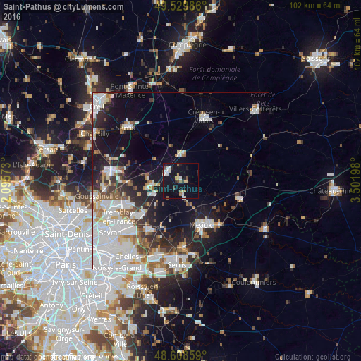
Analysis of Saint-Pathus night lights 2016
Square area 10x10 km:
 2.98%
2.98%90-99
2.98%80-89
3.27%70-79
0.15%60-69
2.08%50-59
2.68%40-49
1.64%30-39
1.04%20-29
2.53%10-19
30.65%0-9
50%Square area 50x50 km:
8%90-99
5.68%80-89
1.93%70-79
1.61%60-69
2.39%50-59
2.54%40-49
2.15%30-39
2.68%20-29
5.09%10-19
11.69%0-9
56.22%Clear (daylight) street map image can be seen on geolist.org.
Map coordinates:
49° 31' 47.5" North, 2° 5' 44.6" East
49° 4' 16.9" North, 2° 47' 55.9" East
48° 36' 30.9" North, 3° 30' 7.1" East
Some cities around Saint-Pathus sort by population:
• Meaux
13.7 km =8.5 mi,  154°
154°
• Mitry-Mory
16.5 km =10.3 mi,  233°
233°
• Claye-Souilly
16.3 km =10.1 mi,  210°
210°
• Dammartin-en-Goële
9 km =5.6 mi,  257°
257°
• Othis
9 km =5.6 mi,  271°
271°
• Esbly
18.5 km =11.5 mi,  176°
176°
• Nanteuil-lès-Meaux
17.3 km =10.7 mi,  155°
155°
• Trilport
16.9 km =10.5 mi,  138°
138°
2977709 (p: 5,296)
Sources (retrieved 2019-11-25):
» Earth at Night: Flat Maps 2012, 2016