Coulommiers night lights from space
Night Light of Coulommiers (Île-de-France) from space (France) Src. Average luminocity for 10x10km area is 11.2003% and for 50x50km: 8.1506%.
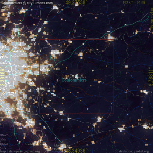
Analysis of Coulommiers night lights 2016
Square area 10x10 km:
 1.7%
1.7%90-99
1.99%80-89
3.13%70-79
0%60-69
0%50-59
0.85%40-49
0.85%30-39
1.14%20-29
1.56%10-19
1.99%0-9
86.79%Square area 50x50 km:
1.28%90-99
1.36%80-89
0.63%70-79
0.63%60-69
0.91%50-59
0.88%40-49
0.98%30-39
1.31%20-29
2.47%10-19
5.47%0-9
84.07%Clear (daylight) street map image can be seen on geolist.org.
Map coordinates:
49° 16' 31.4" North, 2° 22' 54.7" East
48° 48' 52.2" North, 3° 5' 5.9" East
48° 20' 57.7" North, 3° 47' 17.2" East
Some cities around Coulommiers sort by population:
• Meaux
22.1 km =13.7 mi,  317°
317°
• La Ferté-sous-Jouarre
15.5 km =9.6 mi,  11°
11°
• Tournan-en-Brie
24.3 km =15.1 mi,  250°
250°
• Esbly
22.3 km =13.9 mi,  296°
296°
• Nanteuil-lès-Meaux
18.8 km =11.7 mi,  312°
312°
• Trilport
18.6 km =11.6 mi,  328°
328°
• Fontenay-Trésigny
19.8 km =12.3 mi,  232°
232°
• Quincy-Voisins
18.1 km =11.2 mi, 302°
3023240 (p: 15,274)
Sources (retrieved 2019-11-25):
» Earth at Night: Flat Maps 2012, 2016