Esbly night lights from space
Night Light of Esbly (Île-de-France) from space (France) Src. Average luminocity for 10x10km area is 42.6946% and for 50x50km: 32.6048%.
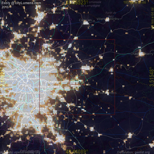
Analysis of Esbly night lights 2016
Square area 10x10 km:
 8.1%
8.1%90-99
9.23%80-89
3.13%70-79
3.69%60-69
3.84%50-59
5.82%40-49
3.13%30-39
10.65%20-29
23.15%10-19
25.99%0-9
3.27%Square area 50x50 km:
10.77%90-99
7.58%80-89
2.5%70-79
2.4%60-69
3.3%50-59
3.05%40-49
3.05%30-39
3.6%20-29
6.01%10-19
11.6%0-9
46.14%Clear (daylight) street map image can be seen on geolist.org.
Map coordinates:
49° 21' 54.8" North, 2° 6' 33.2" East
48° 54' 18.7" North, 2° 48' 44.5" East
48° 26' 27.2" North, 3° 30' 55.7" East
Some cities around Esbly sort by population:
• Meaux
7.8 km =4.8 mi,  38°
38°
• Lagny-sur-Marne
8.2 km =5.1 mi,  238°
238°
• Claye-Souilly
10.3 km =6.4 mi,  295°
295°
• Bussy-Saint-Georges
10.8 km =6.7 mi,  228°
228°
• Thorigny-sur-Marne
7.2 km =4.5 mi,  253°
253°
• Saint-Thibault-des-Vignes
10.4 km =6.5 mi, 248°
• Nanteuil-lès-Meaux
6.7 km =4.2 mi,  66°
66°
• Quincy-Voisins
4.6 km =2.9 mi,  95°
95°
3019854 (p: 5,609)
Sources (retrieved 2019-11-25):
» Earth at Night: Flat Maps 2012, 2016