La Ferté-sous-Jouarre night lights from space
Night Light of La Ferté-sous-Jouarre (Île-de-France) from space (France) Src. Average luminocity for 10x10km area is 8.794% and for 50x50km: 6.9658%.
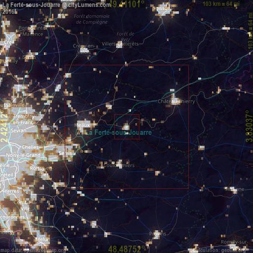
Analysis of La Ferté-sous-Jouarre night lights 2016
Square area 10x10 km:
 1.56%
1.56%90-99
1.28%80-89
0%70-79
0.57%60-69
2.41%50-59
1.56%40-49
0.57%30-39
0.43%20-29
1.85%10-19
1.14%0-9
88.64%Square area 50x50 km:
1.02%90-99
1.16%80-89
0.73%70-79
0.47%60-69
0.87%50-59
0.74%40-49
0.81%30-39
0.9%20-29
2.03%10-19
4.88%0-9
86.39%Clear (daylight) street map image can be seen on geolist.org.
Map coordinates:
49° 24' 39.6" North, 2° 25' 26.8" East
48° 57' 5" North, 3° 7' 38.1" East
48° 29' 15.1" North, 3° 49' 49.3" East
Some cities around La Ferté-sous-Jouarre sort by population:
• Meaux
18.2 km =11.3 mi,  273°
273°
• Château-Thierry
22.7 km =14.1 mi,  62°
62°
• Coulommiers
15.5 km =9.6 mi,  191°
191°
• Esbly
23.6 km =14.7 mi,  257°
257°
• Nanteuil-lès-Meaux
17.1 km =10.6 mi, 261°
• Saint-Pathus
27.4 km =17 mi,  299°
299°
• Trilport
12.9 km =8 mi, 272°
• Quincy-Voisins
19.2 km =11.9 mi,  253°
253°
3009481 (p: 9,443)
Sources (retrieved 2019-11-25):
» Earth at Night: Flat Maps 2012, 2016