Quincy-Voisins night lights from space
Night Light of Quincy-Voisins (Île-de-France) from space (France) Src. Average luminocity for 10x10km area is 32.2088% and for 50x50km: 25.0292%.
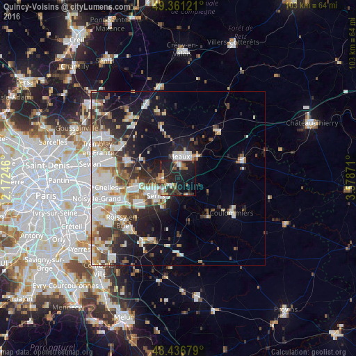
Analysis of Quincy-Voisins night lights 2016
Square area 10x10 km:
 3.13%
3.13%90-99
5.11%80-89
3.13%70-79
2.56%60-69
3.84%50-59
4.83%40-49
3.84%30-39
6.53%20-29
21.45%10-19
32.1%0-9
13.49%Square area 50x50 km:
6.01%90-99
6.17%80-89
2.1%70-79
1.83%60-69
2.9%50-59
2.76%40-49
2.9%30-39
3.35%20-29
5.7%10-19
11.22%0-9
55.06%Clear (daylight) street map image can be seen on geolist.org.
Map coordinates:
49° 21' 40.4" North, 2° 10' 20.9" East
48° 54' 4.1" North, 2° 52' 32.1" East
48° 26' 12.4" North, 3° 34' 43.4" East
Some cities around Quincy-Voisins sort by population:
• Meaux
6.6 km =4.1 mi,  2°
2°
• Lagny-sur-Marne
12.2 km =7.6 mi,  251°
251°
• Bussy-Saint-Georges
14.4 km =8.9 mi,  242°
242°
• Thorigny-sur-Marne
11.6 km =7.2 mi,  262°
262°
• Saint-Thibault-des-Vignes
14.7 km =9.1 mi, 256°
• Esbly
4.6 km =2.9 mi,  275°
275°
• Nanteuil-lès-Meaux
3.5 km =2.2 mi,  25°
25°
• Trilport
8.3 km =5.2 mi,  41°
41°
2984677 (p: 5,018)
Sources (retrieved 2019-11-25):
» Earth at Night: Flat Maps 2012, 2016