Saint-Maurice night lights from space
Night Light of Saint-Maurice (Île-de-France) from space (France) Src. Average luminocity for 10x10km area is 99.2884% and for 50x50km: 74.707%.
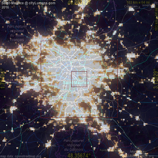
Analysis of Saint-Maurice night lights 2016
Square area 10x10 km:
 79.4%
79.4%90-99
18.04%80-89
2.27%70-79
0.28%60-69
0%50-59
0%40-49
0%30-39
0%20-29
0%10-19
0%0-9
0%Square area 50x50 km:
35.89%90-99
19.05%80-89
5.16%70-79
5.06%60-69
5.54%50-59
4.49%40-49
5.32%30-39
4.36%20-29
5.02%10-19
5.5%0-9
4.61%Clear (daylight) street map image can be seen on geolist.org.
Map coordinates:
49° 16' 57.4" North, 1° 43' 26.5" East
48° 49' 18.6" North, 2° 25' 37.8" East
48° 21' 24.3" North, 3° 7' 49" East
Some cities around Saint-Maurice sort by population:
• Créteil
4.3 km =2.7 mi,  138°
138°
• Vitry-sur-Seine
4.2 km =2.6 mi,  204°
204°
• Ivry-sur-Seine
3.2 km =2 mi,  257°
257°
• Maisons-Alfort
1.4 km =0.9 mi, 141°
• Vincennes
3.1 km =1.9 mi,  14°
14°
• Alfortville
1.9 km =1.2 mi, 195°
• Charenton-le-Pont
1.1 km =0.7 mi,  271°
271°
• Joinville-le-Pont
3.5 km =2.2 mi,  83°
83°
2978170 (p: 14,282)
Sources (retrieved 2019-11-25):
» Earth at Night: Flat Maps 2012, 2016