Saint-Fargeau-Ponthierry night lights from space
Night Light of Saint-Fargeau-Ponthierry (Île-de-France) from space (France) Src. Average luminocity for 10x10km area is 48.1905% and for 50x50km: 34.8805%.
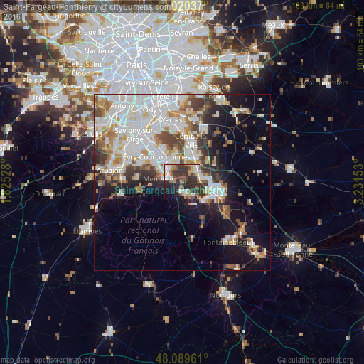
Analysis of Saint-Fargeau-Ponthierry night lights 2016
Square area 10x10 km:
 8.04%
8.04%90-99
8.63%80-89
3.27%70-79
5.95%60-69
4.46%50-59
8.33%40-49
7.74%30-39
20.54%20-29
19.49%10-19
10.86%0-9
2.68%Square area 50x50 km:
10.6%90-99
8.87%80-89
2.54%70-79
3.36%60-69
3.74%50-59
3.06%40-49
3.86%30-39
3.93%20-29
5.39%10-19
11.26%0-9
43.39%Clear (daylight) street map image can be seen on geolist.org.
Map coordinates:
49° 1' 13.3" North, 1° 49' 31" East
48° 33' 25.7" North, 2° 31' 42.2" East
48° 5' 22.6" North, 3° 13' 53.5" East
Some cities around Saint-Fargeau-Ponthierry sort by population:
• Corbeil-Essonnes
6.2 km =3.9 mi,  331°
331°
• Savigny-le-Temple
4.4 km =2.7 mi,  64°
64°
• Mennecy
6.4 km =4 mi,  282°
282°
• Ponthierry
2.9 km =1.8 mi,  155°
155°
• Vert-Saint-Denis
6.9 km =4.3 mi,  79°
79°
• Cesson
5.9 km =3.7 mi, 84°
• Nandy
3.8 km =2.4 mi,  41°
41°
• Villabé
6.7 km =4.2 mi,  302°
302°
2980169 (p: 12,097)
Sources (retrieved 2019-11-25):
» Earth at Night: Flat Maps 2012, 2016