Ponthierry night lights from space
Night Light of Ponthierry (Île-de-France) from space (France) Src. Average luminocity for 10x10km area is 37.6994% and for 50x50km: 30.7708%.
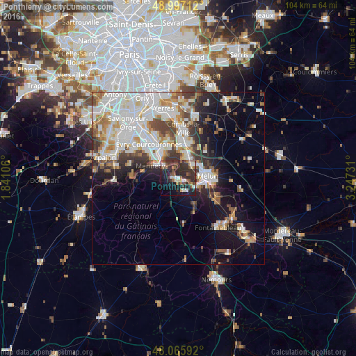
Analysis of Ponthierry night lights 2016
Square area 10x10 km:
 4.61%
4.61%90-99
5.21%80-89
3.13%70-79
3.27%60-69
4.02%50-59
5.95%40-49
7.44%30-39
15.03%20-29
22.17%10-19
19.2%0-9
9.97%Square area 50x50 km:
8.49%90-99
7.88%80-89
2.34%70-79
3.11%60-69
3.49%50-59
2.83%40-49
3.54%30-39
3.53%20-29
5.03%10-19
10.62%0-9
49.15%Clear (daylight) street map image can be seen on geolist.org.
Map coordinates:
48° 59' 49.6" North, 1° 50' 27.8" East
48° 32' 1.2" North, 2° 32' 39.1" East
48° 3' 57.3" North, 3° 14' 50.3" East
Some cities around Ponthierry sort by population:
• Savigny-le-Temple
5.3 km =3.3 mi,  32°
32°
• Le Mée-sur-Seine
6.2 km =3.9 mi,  92°
92°
• Dammarie-les-Lys
8 km =5 mi,  103°
103°
• Saint-Fargeau-Ponthierry
2.9 km =1.8 mi,  335°
335°
• Vert-Saint-Denis
6.8 km =4.2 mi,  55°
55°
• Cesson
5.7 km =3.5 mi, 56°
• Nandy
5.7 km =3.5 mi,  14°
14°
• Saintry-sur-Seine
7.9 km =4.9 mi,  332°
332°
2986178 (p: 12,158)
Sources (retrieved 2019-11-25):
» Earth at Night: Flat Maps 2012, 2016