Villabé night lights from space
Night Light of Villabé (Île-de-France) from space (France) Src. Average luminocity for 10x10km area is 67.7262% and for 50x50km: 42.6367%.
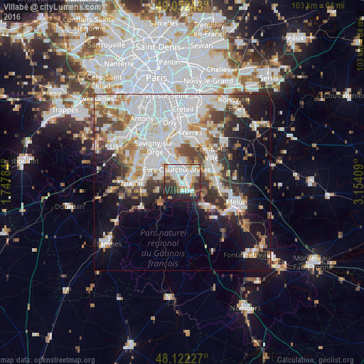
Analysis of Villabé night lights 2016
Square area 10x10 km:
 22.17%
90-99
20.39%80-89
3.57%70-79
7.29%60-69
7.14%50-59
4.46%40-49
4.91%30-39
10.42%20-29
15.77%10-19
3.87%0-9
0%Square area 50x50 km:
14.62%90-99
10.42%80-89
3.24%70-79
3.73%60-69
4.45%50-59
3.58%40-49
4.35%30-39
4.58%20-29
6.18%10-19
12.43%0-9
32.42%Clear (daylight) street map image can be seen on geolist.org.
Map coordinates:
49° 3' 8.7" North, 1° 44' 52.2" East
48° 35' 22.2" North, 2° 27' 3.5" East
48° 7' 20.2" North, 3° 9' 14.7" East
Some cities around Villabé sort by population:
• Évry
4.9 km =3 mi,  350°
350°
• Corbeil-Essonnes
3.3 km =2.1 mi,  55°
55°
• Courcouronnes
4.2 km =2.6 mi,  310°
310°
• Mennecy
2.3 km =1.4 mi,  192°
192°
• Lisses
2.5 km =1.6 mi,  304°
304°
• Saint-Germain-lès-Corbeil
4.5 km =2.8 mi,  36°
36°
• Saint-Pierre-du-Perray
4 km =2.5 mi,  53°
53°
• Saintry-sur-Seine
3.3 km =2.1 mi,  76°
76°
2969058 (p: 5,090)
Sources (retrieved 2019-11-25):
» Earth at Night: Flat Maps 2012, 2016