Montmagny night lights from space
Night Light of Montmagny (Île-de-France) from space (France) Src. Average luminocity for 10x10km area is 94.6634% and for 50x50km: 66.3297%.
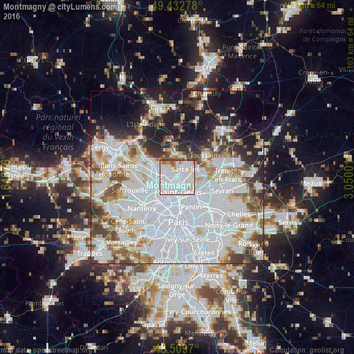
Analysis of Montmagny night lights 2016
Square area 10x10 km:
 62.07%
90-99
22.73%80-89
3.27%70-79
2.56%60-69
4.83%50-59
3.98%40-49
0.57%30-39
0%20-29
0%10-19
0%0-9
0%Square area 50x50 km:
31.34%90-99
15.43%80-89
4.78%70-79
4.19%60-69
5.12%50-59
4.47%40-49
4.7%30-39
4.8%20-29
6.05%10-19
10.69%0-9
8.43%Clear (daylight) street map image can be seen on geolist.org.
Map coordinates:
49° 25' 58" North, 1° 38' 37.5" East
48° 58' 24.2" North, 2° 20' 48.8" East
48° 30' 34.9" North, 3° 3' 0" East
Some cities around Montmagny sort by population:
• Sarcelles
3.5 km =2.2 mi,  40°
40°
• Épinay-sur-Seine
3.2 km =2 mi,  226°
226°
• Pierrefitte-sur-Seine
1.3 km =0.8 mi,  124°
124°
• Deuil-la-Barre
1.5 km =0.9 mi,  284°
284°
• Saint-Brice-sous-Forêt
3.1 km =1.9 mi,  8°
8°
• Villetaneuse
1.7 km =1.1 mi,  192°
192°
• Enghien-les-Bains
2.3 km =1.4 mi,  251°
251°
• Groslay
1.4 km =0.9 mi,  1°
1°
2992287 (p: 14,708)
Sources (retrieved 2019-11-25):
» Earth at Night: Flat Maps 2012, 2016