Rungis night lights from space
Night Light of Rungis (Île-de-France) from space (France) Src. Average luminocity for 10x10km area is 98.2202% and for 50x50km: 71.0221%.
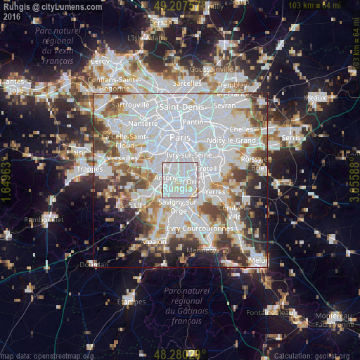
Analysis of Rungis night lights 2016
Square area 10x10 km:
 61.31%
90-99
31.7%80-89
6.99%70-79
0%60-69
0%50-59
0%40-49
0%30-39
0%20-29
0%10-19
0%0-9
0%Square area 50x50 km:
33.42%90-99
17.43%80-89
4.99%70-79
4.75%60-69
5.47%50-59
4.51%40-49
5.81%30-39
5.61%20-29
5.33%10-19
5.49%0-9
7.19%Clear (daylight) street map image can be seen on geolist.org.
Map coordinates:
49° 12' 27.3" North, 1° 38' 58.7" East
48° 44' 45.9" North, 2° 21' 9.9" East
48° 16' 49" North, 3° 3' 21.2" East
Some cities around Rungis sort by population:
• Antony
4.2 km =2.6 mi,  281°
281°
• Thiais
3.8 km =2.4 mi,  56°
56°
• Fresnes
2.5 km =1.6 mi,  295°
295°
• Orly
2.9 km =1.8 mi,  85°
85°
• Chevilly-Larue
2.1 km =1.3 mi,  355°
355°
• Chilly-Mazarin
4.4 km =2.7 mi,  217°
217°
• Villeneuve-le-Roi
3.7 km =2.3 mi,  106°
106°
• Paray-Vieille-Poste
3.6 km =2.2 mi,  168°
168°
2982146 (p: 5,583)
Sources (retrieved 2019-11-25):
» Earth at Night: Flat Maps 2012, 2016