Chevilly-Larue night lights from space
Night Light of Chevilly-Larue (Île-de-France) from space (France) Src. Average luminocity for 10x10km area is 98.6605% and for 50x50km: 73.4075%.
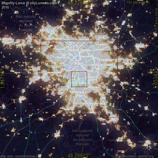
Analysis of Chevilly-Larue night lights 2016
Square area 10x10 km:
 69.46%
90-99
25.28%80-89
5.11%70-79
0.14%60-69
0%50-59
0%40-49
0%30-39
0%20-29
0%10-19
0%0-9
0%Square area 50x50 km:
34.74%90-99
18.28%80-89
5.25%70-79
4.93%60-69
5.63%50-59
4.54%40-49
5.95%30-39
5.47%20-29
5.27%10-19
4.43%0-9
5.53%Clear (daylight) street map image can be seen on geolist.org.
Map coordinates:
49° 13' 33.9" North, 1° 38' 49.8" East
48° 45' 53.1" North, 2° 21' 1.1" East
48° 17' 56.9" North, 3° 3' 12.3" East
Some cities around Chevilly-Larue sort by population:
• Villejuif
3.3 km =2.1 mi,  12°
12°
• Thiais
3.4 km =2.1 mi,  89°
89°
• L'Haÿ-les-Roses
2.4 km =1.5 mi,  328°
328°
• Cachan
3.6 km =2.2 mi,  344°
344°
• Fresnes
2.3 km =1.4 mi,  243°
243°
• Orly
3.6 km =2.2 mi,  121°
121°
• Bourg-la-Reine
2.9 km =1.8 mi,  303°
303°
• Rungis
2.1 km =1.3 mi,  175°
175°
3025314 (p: 20,125)
Sources (retrieved 2019-11-25):
» Earth at Night: Flat Maps 2012, 2016