Villeneuve-le-Roi night lights from space
Night Light of Villeneuve-le-Roi (Île-de-France) from space (France) Src. Average luminocity for 10x10km area is 98.1786% and for 50x50km: 69.3422%.
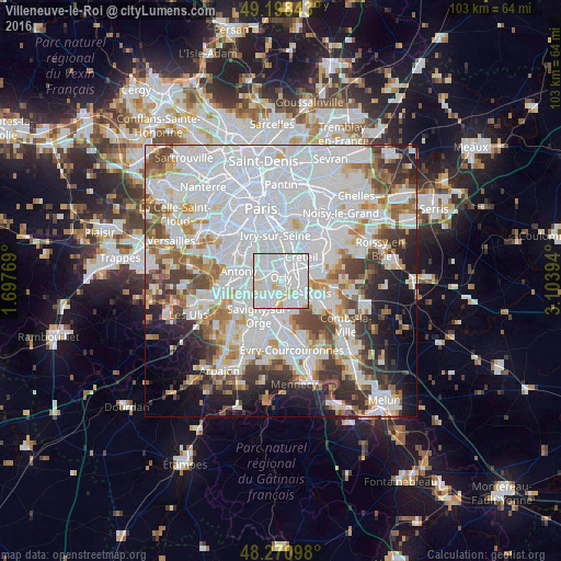
Analysis of Villeneuve-le-Roi night lights 2016
Square area 10x10 km:
 68.45%
90-99
24.11%80-89
7.29%70-79
0%60-69
0.15%50-59
0%40-49
0%30-39
0%20-29
0%10-19
0%0-9
0%Square area 50x50 km:
32.6%90-99
16.88%80-89
4.55%70-79
4.75%60-69
5.55%50-59
4.41%40-49
5.3%30-39
5.17%20-29
5.95%10-19
6.95%0-9
7.89%Clear (daylight) street map image can be seen on geolist.org.
Map coordinates:
49° 11' 54.3" North, 1° 41' 51.7" East
48° 44' 12.6" North, 2° 24' 2.9" East
48° 16' 15.5" North, 3° 6' 14.2" East
Some cities around Villeneuve-le-Roi sort by population:
• Choisy-le-Roi
3.8 km =2.4 mi,  20°
20°
• Athis-Mons
3.6 km =2.2 mi,  191°
191°
• Thiais
3.1 km =1.9 mi,  353°
353°
• Vigneux-sur-Seine
3.9 km =2.4 mi,  166°
166°
• Orly
1.4 km =0.9 mi,  333°
333°
• Paray-Vieille-Poste
3.8 km =2.4 mi,  227°
227°
• Rungis
3.7 km =2.3 mi,  286°
286°
• Ablon-sur-Seine
2.2 km =1.4 mi,  118°
118°
2968546 (p: 17,575)
Sources (retrieved 2019-11-25):
» Earth at Night: Flat Maps 2012, 2016