Péronnas night lights from space
Night Light of Péronnas (Auvergne-Rhône-Alpes) from space (France) Src. Average luminocity for 10x10km area is 35.9361% and for 50x50km: 5.0387%.
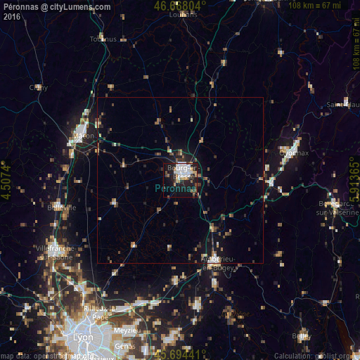
Analysis of Péronnas night lights 2016
Square area 10x10 km:
 8.95%
8.95%90-99
9.09%80-89
1.14%70-79
4.83%60-69
3.41%50-59
3.13%40-49
1.7%30-39
3.55%20-29
8.24%10-19
30.4%0-9
25.57%Square area 50x50 km:
0.55%90-99
0.74%80-89
0.23%70-79
0.51%60-69
0.63%50-59
0.95%40-49
0.74%30-39
0.93%20-29
1.22%10-19
3.94%0-9
89.57%Clear (daylight) street map image can be seen on geolist.org.
Map coordinates:
46° 40' 4.9" North, 4° 30' 26.6" East
46° 11' 0.2" North, 5° 12' 37.9" East
45° 41' 39.9" North, 5° 54' 49.1" East
Some cities around Péronnas sort by population:
• Bourg-en-Bresse
2.8 km =1.7 mi,  25°
25°
• Mâcon
32.8 km =20.4 mi,  296°
296°
• Oyonnax
35.4 km =22 mi,  76°
76°
• Ambérieu-en-Bugey
27.2 km =16.9 mi,  156°
156°
• Meximieux
30.6 km =19 mi,  181°
181°
• Charnay-lès-Mâcon
35.5 km =22.1 mi,  292°
292°
• Lagnieu
32.9 km =20.4 mi, 161°
• Viriat
8 km =5 mi,  2°
2°
2987930 (p: 6,411)
Sources (retrieved 2019-11-25):
» Earth at Night: Flat Maps 2012, 2016