Charnay-lès-Mâcon night lights from space
Night Light of Charnay-lès-Mâcon (Bourgogne-Franche-Comté) from space (France) Src. Average luminocity for 10x10km area is 32.7054% and for 50x50km: 4.4078%.
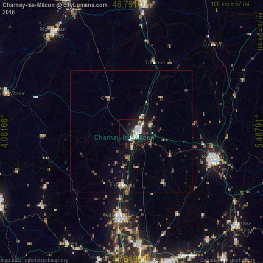
Analysis of Charnay-lès-Mâcon night lights 2016
Square area 10x10 km:
 9.82%
9.82%90-99
9.23%80-89
0.6%70-79
1.79%60-69
2.38%50-59
4.17%40-49
1.49%30-39
1.79%20-29
11.31%10-19
24.26%0-9
33.18%Square area 50x50 km:
0.53%90-99
0.65%80-89
0.29%70-79
0.38%60-69
0.41%50-59
0.74%40-49
0.74%30-39
0.8%20-29
1.16%10-19
3.8%0-9
90.5%Clear (daylight) street map image can be seen on geolist.org.
Map coordinates:
46° 47' 27.9" North, 4° 4' 54" East
46° 18' 27" North, 4° 47' 5.2" East
45° 49' 10.7" North, 5° 29' 16.5" East
Some cities around Charnay-lès-Mâcon sort by population:
• Bourg-en-Bresse
35.7 km =22.2 mi,  108°
108°
• Mâcon
3.4 km =2.1 mi,  77°
77°
• Villefranche-sur-Saône
35.7 km =22.2 mi,  188°
188°
• Gleizé
36 km =22.4 mi, 190°
• Péronnas
35.5 km =22.1 mi, 112°
• Belleville
22.3 km =13.9 mi, 187°
• Tournus
30.4 km =18.9 mi,  17°
17°
• Viriat
33.6 km =20.9 mi,  100°
100°
3026534 (p: 7,019)
Sources (retrieved 2019-11-25):
» Earth at Night: Flat Maps 2012, 2016