Lagnieu night lights from space
Night Light of Lagnieu (Auvergne-Rhône-Alpes) from space (France) Src. Average luminocity for 10x10km area is 16.6161% and for 50x50km: 10.5273%.
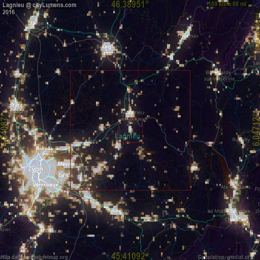
Analysis of Lagnieu night lights 2016
Square area 10x10 km:
 0.45%
0.45%90-99
1.79%80-89
0.89%70-79
1.93%60-69
1.49%50-59
2.38%40-49
2.53%30-39
3.57%20-29
3.57%10-19
31.4%0-9
50%Square area 50x50 km:
1.02%90-99
1.43%80-89
0.89%70-79
1.22%60-69
1.22%50-59
1.57%40-49
1.53%30-39
2.72%20-29
3.8%10-19
8.44%0-9
76.17%Clear (daylight) street map image can be seen on geolist.org.
Map coordinates:
46° 23' 22.2" North, 4° 38' 27.1" East
45° 54' 8.5" North, 5° 20' 38.4" East
45° 24' 39.3" North, 6° 2' 49.6" East
Some cities around Lagnieu sort by population:
• Meyzieu
30.5 km =19 mi,  240°
240°
• Ambérieu-en-Bugey
6.4 km =4 mi,  5°
5°
• Belley
31.1 km =19.3 mi,  120°
120°
• Charvieu-Chavagneux
22.6 km =14 mi,  221°
221°
• Meximieux
11.2 km =7 mi,  273°
273°
• Montluel
22.9 km =14.2 mi,  255°
255°
• Jonage
25.9 km =16.1 mi, 242°
• Tignieu
20.6 km =12.8 mi, 215°
3009073 (p: 6,454)
Sources (retrieved 2019-11-25):
» Earth at Night: Flat Maps 2012, 2016