Meximieux night lights from space
Night Light of Meximieux (Auvergne-Rhône-Alpes) from space (France) Src. Average luminocity for 10x10km area is 14.2262% and for 50x50km: 17.201%.
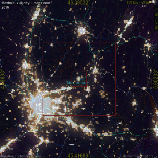
Analysis of Meximieux night lights 2016
Square area 10x10 km:
 0.45%
0.45%90-99
1.93%80-89
1.93%70-79
2.23%60-69
1.04%50-59
1.34%40-49
1.19%30-39
1.34%20-29
3.72%10-19
6.85%0-9
77.98%Square area 50x50 km:
3.74%90-99
3.42%80-89
1.39%70-79
1.66%60-69
1.6%50-59
1.99%40-49
2.01%30-39
3.46%20-29
4.42%10-19
9.43%0-9
66.88%Clear (daylight) street map image can be seen on geolist.org.
Map coordinates:
46° 23' 43.2" North, 4° 29' 45.9" East
45° 54' 29.6" North, 5° 11' 57.1" East
45° 25' 0.6" North, 5° 54' 8.4" East
Some cities around Meximieux sort by population:
• Meyzieu
21.9 km =13.6 mi,  223°
223°
• Ambérieu-en-Bugey
13.1 km =8.1 mi,  64°
64°
• Miribel
21.1 km =13.1 mi,  244°
244°
• Charvieu-Chavagneux
18 km =11.2 mi,  192°
192°
• Montluel
12.6 km =7.8 mi, 240°
• Lagnieu
11.2 km =7 mi,  93°
93°
• Jonage
17.2 km =10.7 mi, 223°
• Tignieu
17.4 km =10.8 mi,  182°
182°
2994094 (p: 7,467)
Sources (retrieved 2019-11-25):
» Earth at Night: Flat Maps 2012, 2016