Nieppe night lights from space
Night Light of Nieppe (Hauts-de-France) from space (France) Src. Average luminocity for 10x10km area is 38.8837% and for 50x50km: 37.2317%.
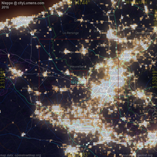
Analysis of Nieppe night lights 2016
Square area 10x10 km:
 5.48%
5.48%90-99
7.89%80-89
4.55%70-79
2.81%60-69
6.82%50-59
6.68%40-49
3.34%30-39
4.14%20-29
14.17%10-19
35.03%0-9
9.09%Square area 50x50 km:
8.79%90-99
6.93%80-89
3.26%70-79
4.3%60-69
5.11%50-59
5.1%40-49
5.72%30-39
5.97%20-29
8.21%10-19
14.8%0-9
31.8%Clear (daylight) street map image can be seen on geolist.org.
Map coordinates:
51° 8' 50.8" North, 2° 7' 55" East
50° 42' 15.3" North, 2° 50' 6.2" East
50° 15' 24.6" North, 3° 32' 17.5" East
Some cities around Nieppe sort by population:
• Lomme
12.7 km =7.9 mi,  122°
122°
• Armentières
3.9 km =2.4 mi, 121°
• Bailleul
7.8 km =4.8 mi,  296°
296°
• Houplines
5.7 km =3.5 mi,  100°
100°
• Pérenchies
10.3 km =6.4 mi,  111°
111°
• Quesnoy-sur-Deûle
11.7 km =7.3 mi,  84°
84°
• Estaires
10 km =6.2 mi,  229°
229°
• La Gorgue
11.2 km =7 mi, 228°
2990392 (p: 7,638)
Sources (retrieved 2019-11-25):
» Earth at Night: Flat Maps 2012, 2016