Armentières night lights from space
Night Light of Armentières (Hauts-de-France) from space (France) Src. Average luminocity for 10x10km area is 50.2433% and for 50x50km: 41.6635%.
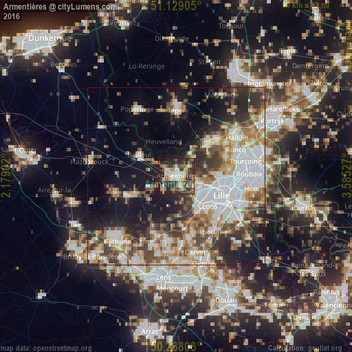
Analysis of Armentières night lights 2016
Square area 10x10 km:
 6.55%
6.55%90-99
8.82%80-89
4.41%70-79
8.96%60-69
6.02%50-59
10.43%40-49
9.22%30-39
12.43%20-29
21.39%10-19
11.63%0-9
0.13%Square area 50x50 km:
10.36%90-99
8.1%80-89
3.77%70-79
4.99%60-69
5.58%50-59
5.52%40-49
6.04%30-39
6.47%20-29
8.38%10-19
15.33%0-9
25.45%Clear (daylight) street map image can be seen on geolist.org.
Map coordinates:
51° 7' 44.6" North, 2° 10' 44.5" East
50° 41' 8.4" North, 2° 52' 55.7" East
50° 14' 17.1" North, 3° 35' 7" East
Some cities around Armentières sort by population:
• Lomme
8.8 km =5.5 mi,  122°
122°
• Lambersart
11.4 km =7.1 mi,  110°
110°
• Haubourdin
11.6 km =7.2 mi,  138°
138°
• Wambrechies
11.7 km =7.3 mi,  91°
91°
• Houplines
2.5 km =1.6 mi,  66°
66°
• Pérenchies
6.4 km =4 mi, 105°
• Nieppe
3.9 km =2.4 mi,  301°
301°
• Quesnoy-sur-Deûle
8.9 km =5.5 mi, 69°
3036903 (p: 26,646)
Sources (retrieved 2019-11-25):
» Earth at Night: Flat Maps 2012, 2016