Estaires night lights from space
Night Light of Estaires (Hauts-de-France) from space (France) Src. Average luminocity for 10x10km area is 25.9666% and for 50x50km: 35.4908%.
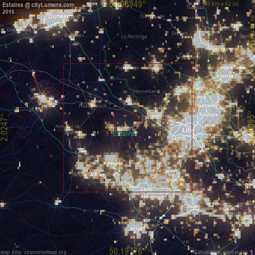
Analysis of Estaires night lights 2016
Square area 10x10 km:
 2.14%
2.14%90-99
2.67%80-89
1.87%70-79
2.67%60-69
2.67%50-59
4.28%40-49
5.61%30-39
4.01%20-29
5.35%10-19
64.17%0-9
4.55%Square area 50x50 km:
7.31%90-99
7.5%80-89
3.4%70-79
4.27%60-69
4.77%50-59
4.71%40-49
5.62%30-39
5.46%20-29
6.93%10-19
15.11%0-9
34.91%Clear (daylight) street map image can be seen on geolist.org.
Map coordinates:
51° 5' 22.2" North, 2° 1' 28.9" East
50° 38' 44.7" North, 2° 43' 40.2" East
50° 11' 51.9" North, 3° 25' 51.4" East
Some cities around Estaires sort by population:
• Béthune
14.3 km =8.9 mi,  205°
205°
• Armentières
11.7 km =7.3 mi,  67°
67°
• Bailleul
10 km =6.2 mi,  3°
3°
• Merville
6.1 km =3.8 mi,  267°
267°
• Houplines
14.3 km =8.9 mi, 67°
• Nieppe
10 km =6.2 mi,  49°
49°
• La Bassée
13.6 km =8.5 mi,  155°
155°
• La Gorgue
1.3 km =0.8 mi,  225°
225°
3019578 (p: 5,979)
Sources (retrieved 2019-11-25):
» Earth at Night: Flat Maps 2012, 2016