Bailleul night lights from space
Night Light of Bailleul (Hauts-de-France) from space (France) Src. Average luminocity for 10x10km area is 17.484% and for 50x50km: 25.5609%.
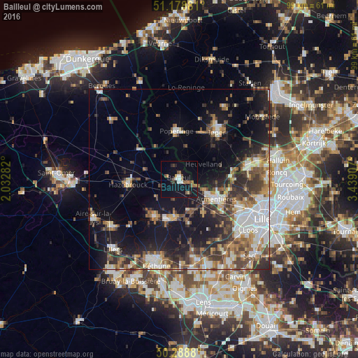
Analysis of Bailleul night lights 2016
Square area 10x10 km:
 2.41%
2.41%90-99
1.87%80-89
0.53%70-79
1.07%60-69
4.41%50-59
2.27%40-49
2.01%30-39
1.07%20-29
2.54%10-19
25%0-9
56.82%Square area 50x50 km:
4.63%90-99
4.13%80-89
2.17%70-79
2.7%60-69
3.47%50-59
4.1%40-49
4.33%30-39
4.59%20-29
6.51%10-19
15.82%0-9
47.54%Clear (daylight) street map image can be seen on geolist.org.
Map coordinates:
51° 10' 43.7" North, 2° 1' 58.2" East
50° 44' 9.3" North, 2° 44' 9.4" East
50° 17' 19.7" North, 3° 26' 20.7" East
Some cities around Bailleul sort by population:
• Armentières
11.7 km =7.3 mi,  118°
118°
• Hazebrouck
14 km =8.7 mi,  264°
264°
• Poperinge, BE
13.1 km =8.1 mi,  357°
357°
• Merville
12.3 km =7.6 mi,  212°
212°
• Houplines
13.4 km =8.3 mi,  109°
109°
• Nieppe
7.8 km =4.8 mi, 116°
• Estaires
10 km =6.2 mi,  183°
183°
• La Gorgue
11 km =6.8 mi,  187°
187°
3035359 (p: 14,884)
Sources (retrieved 2019-11-25):
» Earth at Night: Flat Maps 2012, 2016