Pérenchies night lights from space
Night Light of Pérenchies (Hauts-de-France) from space (France) Src. Average luminocity for 10x10km area is 66.5548% and for 50x50km: 46.2967%.
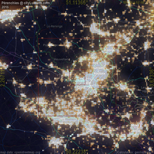
Analysis of Pérenchies night lights 2016
Square area 10x10 km:
 18.98%
90-99
14.57%80-89
3.88%70-79
10.96%60-69
6.28%50-59
9.49%40-49
9.09%30-39
20.72%20-29
6.02%10-19
0%0-9
0%Square area 50x50 km:
11.57%90-99
9.42%80-89
4.04%70-79
5.7%60-69
6.15%50-59
6.23%40-49
6.86%30-39
6.89%20-29
9.3%10-19
15.97%0-9
17.86%Clear (daylight) street map image can be seen on geolist.org.
Map coordinates:
51° 6' 49.1" North, 2° 16' 1.6" East
50° 40' 12.5" North, 2° 58' 12.9" East
50° 13' 20.6" North, 3° 40' 24.1" East
Some cities around Pérenchies sort by population:
• Lomme
3.2 km =2 mi,  158°
158°
• Lambersart
5 km =3.1 mi,  116°
116°
• Armentières
6.4 km =4 mi,  285°
285°
• Saint-André-lez-Lille
5.6 km =3.5 mi,  93°
93°
• Marquette-lez-Lille
6.8 km =4.2 mi,  84°
84°
• Wambrechies
5.6 km =3.5 mi, 75°
• Houplines
4.8 km =3 mi,  305°
305°
• Quesnoy-sur-Deûle
5.3 km =3.3 mi,  23°
23°
2988003 (p: 7,761)
Sources (retrieved 2019-11-25):
» Earth at Night: Flat Maps 2012, 2016