La Gorgue night lights from space
Night Light of La Gorgue (Hauts-de-France) from space (France) Src. Average luminocity for 10x10km area is 26.139% and for 50x50km: 34.8117%.
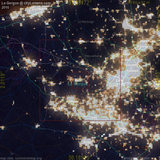
Analysis of La Gorgue night lights 2016
Square area 10x10 km:
 2.14%
2.14%90-99
2.67%80-89
2.01%70-79
3.07%60-69
2.67%50-59
4.68%40-49
4.81%30-39
3.88%20-29
4.55%10-19
65.91%0-9
3.61%Square area 50x50 km:
7.09%90-99
7.49%80-89
3.4%70-79
4.13%60-69
4.59%50-59
4.51%40-49
5.54%30-39
5.38%20-29
6.69%10-19
15.02%0-9
36.16%Clear (daylight) street map image can be seen on geolist.org.
Map coordinates:
51° 4' 54.2" North, 2° 0' 42.8" East
50° 38' 16.4" North, 2° 42' 54.1" East
50° 11' 23.5" North, 3° 25' 5.3" East
Some cities around La Gorgue sort by population:
• Béthune
13.1 km =8.1 mi,  203°
203°
• Armentières
12.9 km =8 mi,  65°
65°
• Bailleul
11 km =6.8 mi,  7°
7°
• Merville
5.2 km =3.2 mi,  276°
276°
• Beuvry
13.6 km =8.5 mi,  188°
188°
• Nieppe
11.2 km =7 mi,  48°
48°
• La Bassée
13.2 km =8.2 mi,  150°
150°
• Estaires
1.3 km =0.8 mi, 45°
3009050 (p: 5,327)
Sources (retrieved 2019-11-25):
» Earth at Night: Flat Maps 2012, 2016