Neuilly-Plaisance night lights from space
Night Light of Neuilly-Plaisance (Île-de-France) from space (France) Src. Average luminocity for 10x10km area is 99.1037% and for 50x50km: 67.7324%.
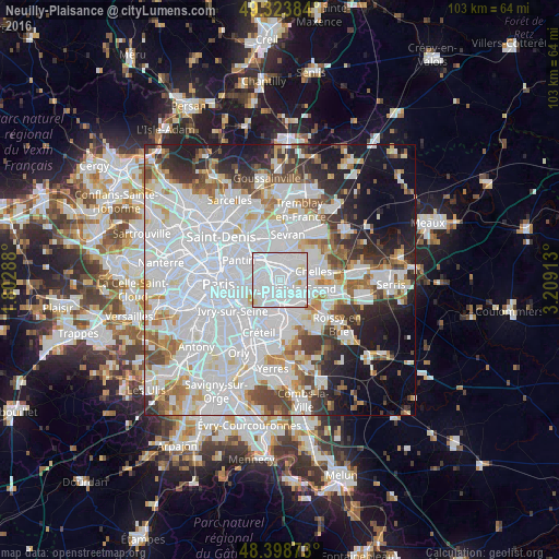
Analysis of Neuilly-Plaisance night lights 2016
Square area 10x10 km:
 75.85%
90-99
21.02%80-89
2.13%70-79
0.99%60-69
0%50-59
0%40-49
0%30-39
0%20-29
0%10-19
0%0-9
0%Square area 50x50 km:
33.04%90-99
16%80-89
4.39%70-79
4.09%60-69
4.83%50-59
4.12%40-49
4.52%30-39
4.56%20-29
6.52%10-19
9.6%0-9
8.34%Clear (daylight) street map image can be seen on geolist.org.
Map coordinates:
49° 19' 25.8" North, 1° 48' 10.4" East
48° 51' 48.3" North, 2° 30' 21.6" East
48° 23' 55.4" North, 3° 12' 32.9" East
Some cities around Neuilly-Plaisance sort by population:
• Fontenay-sous-Bois
2 km =1.2 mi,  239°
239°
• Rosny-sous-Bois
0.9 km =0.6 mi,  326°
326°
• Gagny
3 km =1.9 mi,  42°
42°
• Le Perreux-sur-Marne
1.6 km =1 mi,  196°
196°
• Nogent-sur-Marne
3.4 km =2.1 mi,  209°
209°
• Villemomble
2.3 km =1.4 mi,  348°
348°
• Bry-sur-Marne
3.1 km =1.9 mi,  153°
153°
• Le Raincy
4.2 km =2.6 mi,  17°
17°
2990616 (p: 18,725)
Sources (retrieved 2019-11-25):
» Earth at Night: Flat Maps 2012, 2016