Le Raincy night lights from space
Night Light of Le Raincy (Île-de-France) from space (France) Src. Average luminocity for 10x10km area is 98.2443% and for 50x50km: 64.1185%.
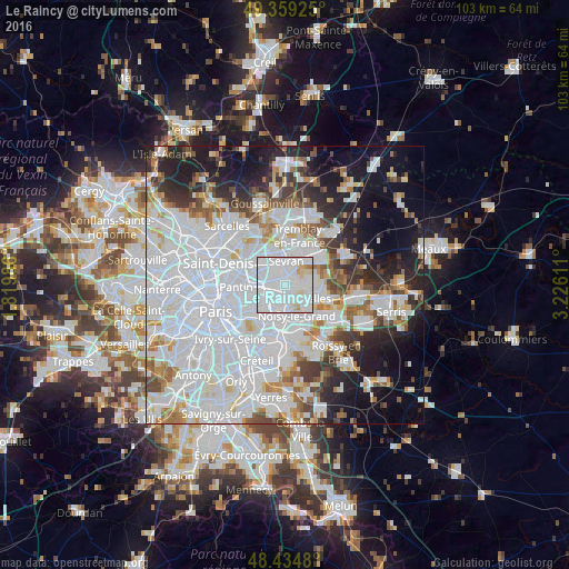
Analysis of Le Raincy night lights 2016
Square area 10x10 km:
 73.58%
90-99
19.18%80-89
5.26%70-79
1.14%60-69
0.85%50-59
0%40-49
0%30-39
0%20-29
0%10-19
0%0-9
0%Square area 50x50 km:
31.44%90-99
14.76%80-89
3.97%70-79
3.51%60-69
4.49%50-59
3.9%40-49
3.91%30-39
4.42%20-29
7.28%10-19
12.35%0-9
9.96%Clear (daylight) street map image can be seen on geolist.org.
Map coordinates:
49° 21' 33.3" North, 1° 49' 11.5" East
48° 53' 57" North, 2° 31' 22.7" East
48° 26' 5.3" North, 3° 13' 34" East
Some cities around Le Raincy sort by population:
• Bondy
2.5 km =1.6 mi,  276°
276°
• Rosny-sous-Bois
3.7 km =2.3 mi,  208°
208°
• Livry-Gargan
2.7 km =1.7 mi,  33°
33°
• Gagny
1.9 km =1.2 mi,  156°
156°
• Clichy-sous-Bois
2.5 km =1.6 mi,  60°
60°
• Villemomble
2.4 km =1.5 mi,  223°
223°
• Montfermeil
4.1 km =2.5 mi,  91°
91°
• Les Pavillons-sous-Bois
1.5 km =0.9 mi,  305°
305°
3002401 (p: 13,246)
Sources (retrieved 2019-11-25):
» Earth at Night: Flat Maps 2012, 2016