Les Pavillons-sous-Bois night lights from space
Night Light of Les Pavillons-sous-Bois (Île-de-France) from space (France) Src. Average luminocity for 10x10km area is 98.956% and for 50x50km: 65.0407%.
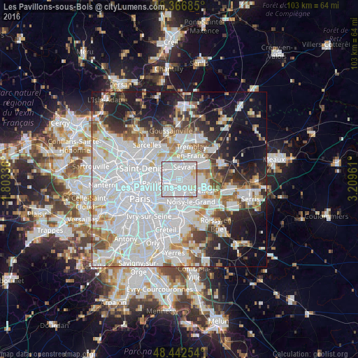
Analysis of Les Pavillons-sous-Bois night lights 2016
Square area 10x10 km:
 79.55%
90-99
15.77%80-89
4.12%70-79
0.57%60-69
0%50-59
0%40-49
0%30-39
0%20-29
0%10-19
0%0-9
0%Square area 50x50 km:
31.79%90-99
15.13%80-89
4.17%70-79
3.65%60-69
4.52%50-59
3.92%40-49
3.82%30-39
4.35%20-29
7.17%10-19
12.7%0-9
8.79%Clear (daylight) street map image can be seen on geolist.org.
Map coordinates:
49° 22' 0.7" North, 1° 48' 12.1" East
48° 54' 24.6" North, 2° 30' 23.3" East
48° 26' 33.1" North, 3° 12' 34.6" East
Some cities around Les Pavillons-sous-Bois sort by population:
• Aulnay-sous-Bois
3.6 km =2.2 mi,  345°
345°
• Bondy
1.4 km =0.9 mi,  245°
245°
• Livry-Gargan
3 km =1.9 mi,  62°
62°
• Noisy-le-Sec
3.5 km =2.2 mi,  240°
240°
• Gagny
3.3 km =2.1 mi,  143°
143°
• Clichy-sous-Bois
3.4 km =2.1 mi,  83°
83°
• Villemomble
2.7 km =1.7 mi,  190°
190°
• Le Raincy
1.5 km =0.9 mi,  125°
125°
3000060 (p: 19,730)
Sources (retrieved 2019-11-25):
» Earth at Night: Flat Maps 2012, 2016