Tignieu night lights from space
Night Light of Tignieu (Auvergne-Rhône-Alpes) from space (France) Src. Average luminocity for 10x10km area is 35.254% and for 50x50km: 25.699%.
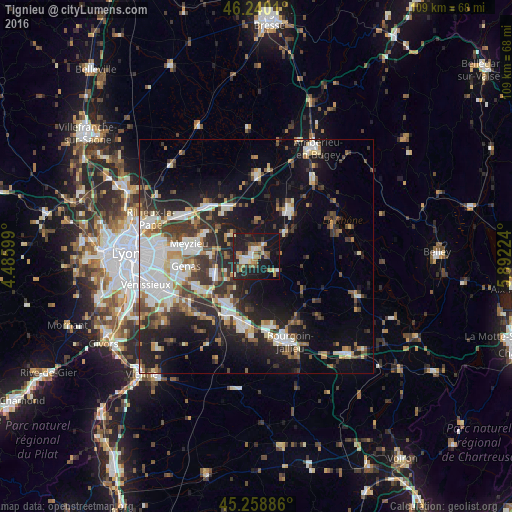
Analysis of Tignieu night lights 2016
Square area 10x10 km:
 4.92%
4.92%90-99
4.13%80-89
3.97%70-79
4.92%60-69
6.67%50-59
4.29%40-49
3.97%30-39
3.97%20-29
13.81%10-19
42.06%0-9
7.3%Square area 50x50 km:
5.16%90-99
5%80-89
2.01%70-79
2.48%60-69
2.74%50-59
3.15%40-49
3.31%30-39
4.76%20-29
7.87%10-19
15.55%0-9
47.96%Clear (daylight) street map image can be seen on geolist.org.
Map coordinates:
46° 14' 24.4" North, 4° 29' 9.6" East
45° 45' 5.9" North, 5° 11' 20.8" East
45° 15' 31.9" North, 5° 53' 32.1" East
Some cities around Tignieu sort by population:
• Meyzieu
14.5 km =9 mi,  276°
276°
• Genas
14.7 km =9.1 mi,  261°
261°
• L’Isle-d’Abeau
14.9 km =9.3 mi,  169°
169°
• Charvieu-Chavagneux
3 km =1.9 mi,  266°
266°
• Saint-Quentin-Fallavier
13.4 km =8.3 mi,  206°
206°
• La Verpillière
13.5 km =8.4 mi,  194°
194°
• Saint-Bonnet-de-Mure
14.2 km =8.8 mi,  241°
241°
• Jonage
12.1 km =7.5 mi,  294°
294°
2972605 (p: 5,244)
Sources (retrieved 2019-11-25):
» Earth at Night: Flat Maps 2012, 2016