Charvieu-Chavagneux night lights from space
Night Light of Charvieu-Chavagneux (Auvergne-Rhône-Alpes) from space (France) Src. Average luminocity for 10x10km area is 39.1727% and for 50x50km: 29.3589%.
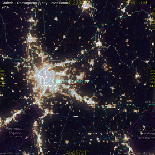
Analysis of Charvieu-Chavagneux night lights 2016
Square area 10x10 km:
 4.39%
4.39%90-99
5.15%80-89
2.88%70-79
4.7%60-69
9.24%50-59
5.45%40-49
3.64%30-39
7.58%20-29
28.79%10-19
27.27%0-9
0.91%Square area 50x50 km:
7.16%90-99
5.8%80-89
2.19%70-79
2.79%60-69
2.83%50-59
3.44%40-49
3.51%30-39
4.94%20-29
8.65%10-19
15.72%0-9
42.97%Clear (daylight) street map image can be seen on geolist.org.
Map coordinates:
46° 14' 18.5" North, 4° 26' 48.8" East
45° 45' 0" North, 5° 9' 0" East
45° 15' 26" North, 5° 51' 11.3" East
Some cities around Charvieu-Chavagneux sort by population:
• Meyzieu
11.6 km =7.2 mi,  279°
279°
• Genas
11.7 km =7.3 mi,  259°
259°
• Montluel
13.4 km =8.3 mi,  327°
327°
• Saint-Quentin-Fallavier
12.2 km =7.6 mi,  193°
193°
• La Verpillière
12.9 km =8 mi,  181°
181°
• Saint-Bonnet-de-Mure
11.5 km =7.1 mi,  234°
234°
• Jonage
9.5 km =5.9 mi,  302°
302°
• Tignieu
3 km =1.9 mi,  86°
86°
3026451 (p: 8,506)
Sources (retrieved 2019-11-25):
» Earth at Night: Flat Maps 2012, 2016